


Budanilkantha-09, Kathmandu
Nepal
+977-9803458339
info@experiencehimalayaadventure.com
| Last Booking Date |
|---|
| 2026-11-30 |
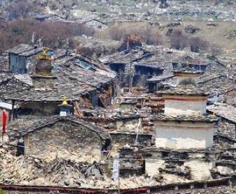
Manaslu Trekking region is
geographically and culturally charming place in Nepal and is considered one of
the excellent trekking destinations in Nepal Himalayas. Manaslu offers you the
huge mountain scenery, wonderful Tibetan culture, ancient monasteries, typical
Nepalese lifestyle, lovely forests with rich flora and fauna and leading ethnic
society in Nepal. This trekking is one of the well-known trails in Nepal. This
trek was officially open for tourists in 1991, but mountaineering expeditions
have long had access to the area. Mount Manaslu (8163m) is situated near to the
border of Nepal. This is eight highest mountain of the world. The name Manaslu
means "The Spirit Mountain" in local language.
You can drive to Arughat Bazaar or
Soti Khola. The trail goes through the Budhi Gandaki River passing different
ethnic groups village, this is cultural trek rather than mountain scenery at
the low elevation. The trail leads us continue to Budhi Gandaki valley through
the Tibetan villages with beautiful mountain sceneries and old Monasteries and
cross the Larkya La pass then join with Annapurna Circuit route. Manaslu
Circuit Trek can make shorter or longer. You can come back towards Besishahar
or continue towards Manang, cross Thorang La pass and fly to Pokhara from Jomsom.
Duration: 17 days
Type of the Trek: Tea House, Home
Stay, Camping
Activities: Trekking, Culture Tours
Best Months: September to November and
March to May
Maximum Altitude: 5180m (Larkya La
Pass)
Grade: Strenuous
*Walk along the rough Budhi Gandaki
Valley, a valley of Tibetan people behind Manaslu.
*Great Mountain Scenery, old Buddhist
Monasteries, Tibetan Culture and high pass crossing.
Day 1: Arrive in Kathmandu (1350m)
Our representative will meet you
outside the customs and immigration area at the airport. He or She will brief
you on the immediate arrangements and escort you to your hotel. The trip leader
will hold a short briefing in the hotel regarding trek arrangements and general
orientation to Kathmandu.
Day 2: Sightseeing in Kathmandu Valley
Today, we visit the most historical
and Spiritual attractions in Kathmandu which are also listed in world heritage
sites. We visit Durbar Square, Swayambhunath (Monkey temple), Bouddhanath,
which is one of the largest Stupa in the world and the sacred Hindu temple of
Pashupatinath.
Day 3: Drive to Arughat (600m) and
then Soti Khola (720m / 8-9 hrs)
After early breakfast, we drive from
Kathmandu to Arughat following the Kathmandu Pokhara highway. While passing the
ridge of Kathmandu valley, we have glimpse of Annapurna, Manaslu, Ganesh Himal
and Langtang Himal, nice terraces and green hills. We cross the Trishuli Khola
on a bridge and drive through Dhading besi, passing Murali Bhanjyang,
Nigalpani, Gola Bhanjyang and arrive in Arughat. The village of Arughat is in
two parts, on opposite sides of the Budhi Gandaki. Arughat Bazaar is large,
clean and prosperous with hotels and shops. From here we drive further to Soti
Khola by local bus. Here are some hotels, shops and small camping ground.
Day 4: Trek to Machha Khola (925m / 6
hrs)
From Soti Khola, we walk along the new
constructing rough road, not any vehicle. We gently ascend through small forest
and arrive in Armala village, from here it is mostly easy flat route to Labu
besi (2 and half-3hrs). There are some small slide areas on the way. We have
very nice views of the valley, nice terraces and some waterfalls. Labu besi
(880m) is nice Gurung village, here are some hotels. From here, it is easy
40min walk to Nauli Khola, here is a hotel and long suspension bridge. The
small new road is finish from this point, after the bridge, the path gradually
descend, flat and second to Khani besi (970m / 40min from Nauli khola), here is
also a local tea shop and few houses. Leaving Khani besi, the path descend down
to the wide bank of Budhi Gandaki river, passing few local hotels, the path
gently ascend to Machha khola (one and half – 2 hrs), this is beautiful walk.
Machha Khola is a village which is situated above a stream with the same name.
There are some hotels, shops and camping grounds. There is a police check post
in Machha khola where we should keep our record.
Day 5: Trek to Yaru Phedi (1140m / 6-7
hrs)
We cross Machha khola by suspension
bridge at last corner, make some minor ups and downs and following in a rocky
ravine, arrive in Khorla besi (970m / 1 and half hrs). There are some hotels
and shops. We cross the river at middle of the village by long suspension
bridge. This is small beautiful village. From here, it is easy 1 and half hrs
walk to Tatopani, hot spring (990m). There are small ups and downs but mostly
gradual ascend. Few minutes later, cross the Budhi Gandaki on a suspension bridge,
gently ascend little higher from the river, follow the river side through
narrow valley then small climb to Dobhan (1010m / 1 hr 15-20 min),There are
some nice waterfalls on the way. In Dobhan, there are some good hotels and
shops. Leaving Dobhan, we gently ascend to Shyauli (45 min, 2 hotels), tiny
settlement and then very easy 15 min walk to Thulo Dunga, here are some old
houses and local tea shops. From here, we walk about 15-20 min further to Yaru
Phedi. At Yaru Phedi, here are few small huts and camping ground. This is not a
village.
Day 6: Trek to Philim (1590m / 6 hrs)
The route ascends gently through
beautiful forest, small climb and arrives on Yaru top (1284m / 25 min) then
descends down to Yaru Bagar. There are some local hotels and shops with
beautiful huge ground. The river valley widens. We cross a long suspension
bridge over the Yaru Khola and ascend a wide set of stone stairs, walk through
very long new steel bridge by the corner of cliff, drop to the river and then
climb more big stone stairs to Thado Bharyang (30-40m / one tea shop). We cross
the Budhi Gandaki River, climb over a small ridge, descend down to river bank
and walk along the river for a while and climb up to the Jagat (1410m / 30 min).
Jagat is very nice village, here are shops, hotels, Police and Manaslu National
Park check post. From Jagat, descend little bit, gently ascend to mini hydro
powerhouse and long suspension bridge. Here is beautiful water fall. After
crossing the bridge, gently descent and then walk through rocky cliff to
Salleri (35-40min / 1430m), there are good views of Sringi Himal as you
continue up along the side of a cliff. From Salleri the path gently ascend
through beautiful hill slope, climb little bit and descend to Sirdibas (1 hr).
We have really nice views of the mountains. The valley widens, we walk through
Ghatta Khola (15min), cross the small stream and continue upstream to a long
suspension bridge (Cham / 10-15 min). We cross the bridge and climb up to
Philim (25 min). This is a large Gurung village with fields of corn and millet.
There are several good camping grounds, good hotels and shops.
 Day 7: Trek to Dyang (1860m / 6 hrs)
The trail turns north in the village
and stays fairly level as it traverses to Chisapani (30-40 min / 1625m /
several good hotels) and then Ekle Bhatti (15 min / few houses). From here it
is very easy 40 -50 min walk to Gampul (no houses, descent, ascent and flat),
from here the path for Chum Valley and Manaslu separate. We take left side path
and descend down to the bridge (6-7 min). After the bridge, climb little bit
and then flat route to Nyak Phedi (1685m / 25 min), here are 2 small hotels.
From here we enter a narrow dramatic gorge section with towering walls and
cross the suspension bridge (15 min), another bridge (25 min / gently climb)
and arrive in Pewa (25min), here are some hotels. It is pleasant walk through
beautiful forest of bamboo and mix. From here, gently ascend through nice
forest, climb small up and arrive in tiny village of Dyang (1 hr). This is
lower part of Nubri region called Kutang and is inhabited primarily by Gurung
who practice Buddhism. Here are some hotels, shops, camping ground and private
houses.
Day 8: Trek to Ghap (2160m / 6 hrs)
From Dyang, the path gently ascend,
little bit climb and then cross the Budhi Gandaki River (30 min) by suspension
bridge. After river crossing, we climb up to Rana Gaon (25min), there are some
houses and fields. We walk through village, fields and gently ascend to Bihi
Phedi (60 min/ 1990m / 2 hotels). There are some ascend, small ups and downs on
the way. After Bihi Phedi, we ascend and descend down to a shop above the river
(30 min). Beyond the shop, we cross the side river by long suspension bridge
(can see many peaks from here) then climb small up. We walk flat, ups and downs
through the beautiful forests, passing Mani wall and arrive in Bur (1hr), there
are some fields and small hotels. From Bur, the path gently ascends, flat and
little bit climb through small forest and landslide areas then contours to beginning
of Ghap village (30-40 min). We continue to walk passing Mani walls, some
hotels, old Stupas and cross Budhi Gandaki River then arrive in second part of
Ghap. There are also many fields and nice hotels. The camping ground is in last
part of the village (30-40 min from beginning of village).
Day 9: Trek to Lho (3180m / 7-8 hrs) 
Leaving Ghap, we gently ascend through
beautiful forest passing several old Mani walls and arrive in Lung Chhyuda
(forest hotel / 30-40 min), here is a nice hotel in the middle of the forest.
After hotel, we cross the river and continue to ascend through nice forest to
another suspension bridge (25-30 min) and climb very steep up to the top of
Namrung village (1 hr 20-30 min). It is very nice walk through beautiful forest
of Pine and Rhododendron, the path is very good and in some places is gentle
climb. From top, we steeply descend down for 10 min to Namrung (2660m), here
are some nice hotels and police check post. From Namrung, the path is mostly
flat and ascent to Bhanjam village (40-50min), here are many old houses, local
tea shop – hotel and lots of farming land. We walk through many old Mani walls
and Stupas on the way. After Bhanjam, we climb steeply up through beautiful
forest to ancient Lihi village (2910m / 50–60 min). This is very nice village,
here are some hotels and one small monastery. Few minutes beyond Lihi, we cross
side river by bridge (15 min) and gently ascend – flat route passing Kakani and
many Mani walls to Shyo village (40 min), here are many houses and one normal
hotel. The views now start to get spectacular. Manaslu (8163m), Manaslu North (7157m)
and Naike peak (6211m) appear at the head of the valley. We ascend through more
fields to the small village of Shrip, pass a stream then small climb up to Lho
village (1 hr 15-20 min). There is a stone archway at the entrance, Monastery, Tibetan
style Chhorten and huge Mani wall at the western end. This is large village,
here are many good hotels, camping ground at the end of the village and big
monastery on top of the village. We have wonderful view of Manaslu from this
village.
Day 10: Trek to Sama Gaon (3530m / 4
hrs)
We climb up to the monastery (15-20
min), after visit monastery, take higher route which is very easy. From
Monastery, it is flat route for a while, small up to the new suspension bridge
(15-20 min) and then gently descend down to river, cross river by local bridge
and then gently climb up to Syala village (3520m / 1 hr 30 min from monastery),
here are many hotels. From here we get wonderful views of Himalchuli, Ngadi
Chuli (Peak 29) and Manaslu. 10 min later from Shyala, we cross a stream by
suspension bridge, gently descend and ascend to another long suspension bridge
(10 min). After the bridge, the path gently descends and walks across fields of
wheat and buckwheat, past Chhorten and large Kani. Beyond the Kani descend to a
large collection of Mani stones, arrive in the main village (35-40 min), here
are many good hotels, shops, Police and Manaslu Conservation Area check post.
In the afternoon, we hike up to the old Gompa above the village and wander
around the village.
Day 11: Explore around Sama Gaon.
Today, we visit Punggen Gompa (3870m).
Climb the ridge to the south of Sama Gaon to the Punggen Gompa which is hidden
behind the ridge in front of Manaslu. We can also make a day hike to Birendra
Taal, the glacial lake at 3450m.
Day 12: Trek to Samdo (3690m / 4 hrs)
Today is also another day of
incredible mountain views, we follow the valley floor which has now turned
north again, follow it to a bridge over a side stream which is flowing down
from Manaslu base camp (25 min). We passes several Mani walls, old Stupas as
the valley begin to widen. It is an easy trail above the river past Juniper and
Birch forests and the stone huts of Kyonggma Kharka then get rougher as it
reaches a ridge. Descend little bit and cross the river and climb steeply (10
min) onto a promontory between two forks of the river. From stone arch we can
see a large Kani. Finally we pass through the Kani to find old herding
settlement of Samdo nestled behind a ridge. The people of Samdo are Tibetan and
were ceded the land by the king of Jumla over 500 years ago. It was major
trading point of Tibet and India long time ago. In the afternoon we walk around
the village, where the people live an essential Tibetan lifestyle, herding
their Yaks, Sheep and Goats. From Samdo, we can see wonderful views of Simnang
Himal – 6251m, Ngadi Chuli (Peak 29) – 7871m, Himal Chuli – 7331m and Samdo
Peak – 6335m but we can't see Manaslu.
Day 13: Trek to Dharmashala, / Larkya
Phedi (4470m / 4 hrs)
From Samdo, we gently descend on a
wide, past many fields, old Mani wall, descends to the river (25 min), cross it
by bridge. Here is a small hydro power house. After bridge, we climb gently
through beautiful green slope to small stream (30 min). From this stream,
gently ascend and climb to small top through Juniper bushes (50 min). We have
very nice views of Samdo Peak, Manaslu North, and Manaslu). From here, we
descend and ascend to Dharamshala, the high camp for the Larkya La pass. We have
breathtaking Mountains view (Samdo peak, Naike and Larke peak) and possible to
see many blue sheep around here. Here are fixed tents and some small ground for
camp.
Day 14: Cross Larkya La (5120m / 4
hrs), camp at Bimthang (3720m / 4 hrs) 
Today, we start walk early in the
morning. We climb up the ridge in front of the rest house, eventually becoming
a long, gentle climb beside a moraine. Cross a small ridge, descend a bit to a
lake (1 hr 30-40 min), keep climbing the ridge to the top of the moraine and
then easy flat for a while to small tea shop (35 – 40 min). From tea shop, we
continue to climb, stay on the moraine to a small ridge (40-50 min), descend
little bit to flat ground (dry lake) and then gently climb up to the pass (30-40
min). We have wonderful panoramic views of Himlung Himal (7126m), Cheo Himal
(6820m), Larkya peak and some others. There are lots of prayer flags and Cairns
on the top. From this first top, we gently descend and ascend for 10-15 min to
another (second) top. From the pass, we descend along the top of a moraine to
the west, then steeply and traverses scare slopes. It makes a long set of
steep, rough switchbacks, crosses the moraine and then descend more gently. We
make final long, steep, slippery descend on loose gravel to another grassy
moraine (bottom / 1 hrs 30-40 min). From bottom, the trail becomes better and
easier, we descend along the grassy moraine to a small meadow / small tea shop
(25-30 min) and a spring. The trail turns a corner, the valley becomes larger
and the trail heads down to a large meadow, Bimthang (1 hr 20-30 min). In
Tibetan language, Bimthang means "plain of sand". In the ancient time
it was major trading point. Bimthang was also a Khampa guerrilla staging area
during the 1970s. This is huge valley surrounded by high peaks. Here are many
good hotels and beautiful green ground. We have wonderful views of Manaslu and
many other surrounding mountains.
Day 15: Trek to Tilche (2300m / 6-7
hrs)
We drop from the Bimthang meadow and
cross a glacial stream by bridge (20-25 min). We have magnificent views of the
mountains around. Climb (few minutes) over the side of the moraine and descend
into a pine and rhododendron forest to Hompuk (Habu / 15-20 min). The trail
descends, switch backing down to a fork of the Dudh Khola then follow the river
through forests to Chauli Kharka, and here is a hotel and beautiful ground in
the middle of the forest (1 hr 30-40 min). From here, we descend down to the
valley floor, ascend little bit then gently descend through beautiful dense
forest to Surki Khola (1hr 20-30 min). Here are also some nice hotels and few
farming lands. Leaving Surti Khola, it is flat route for a while, gentle ascend
(10 min), steep climb for 10-15 minutes and then descend down through beautiful
forest of Pine, Rhododendron and bamboo to a small stream where is a small farm
(15 min) and old huts in other side of the river. It is very easy short walk to
Gho village (2560m / 15 min). This is beautiful small village, here are several
good hotels. From Gho, we descend for a while, walk through beautiful forest,
almost flat route and then join with new constructing road (30 min). After join
with road it is very easy walk, descend to Tilche (30-40 min). We walk along
the new road all the way to Tilche. At the foot of the valley we can see part
of the Lamjung Himal above the Marshyangdi valley. This is large Gurung
village, here are many nice hotels and shops.
Day 16: Trek to Dharapani (1860m / 1
hr 15 min), Drive to Besi Sahar (760m / 5 hrs)
Leaving Tilche village, we cross the
Dudh Khola and join with new constructing road. We follow the road all the
time, little bit ascend and long descend by making several switch backs to valley floor and cross the river again by
long suspension bridge. We walk through old part of Dharapani passing some
houses, many Mani walls and Stupas and cross Marshyangdi River by suspension
bridge then climb small up to the main market of Dharapani. Here are many
hotels, shops, ACAP and Police check post. Here we join with main Annapurna
round route. From Dharapani, we drive to Besi Sahar by local jeep. It is long
drive on bumpy jumpy road through very narrow valley. The road is very rough
but when we reach in Ngadi, it becomes better and valley is wider. We will have
very nice views during the drive. We drive through many nice villages and hydro
power. We stop on the way for lunch. Besi Sahar is administrative Head Quarter
of Lamjung district, this is big city, and here are many government offices,
hotels, shops and restaurants. We spend night in one of the best hotel (Gate
Way).
Day 17: Drive to Kathmandu (5-6 hrs)
From Besishahar the road is very good
and wonderful scenery. We join with Pokhara Kathmandu highway in Dumre bazaar.
We have lunch on the way to Kathmandu at nice restaurant. It is very scenic
drive to Kathmandu. In the evening we have farewell dinner at typical Nepali
restaurant with cultural program.
Day 18: Departure from Nepal.
We will escort you to airport for your
departure.
| Detailed Location | Nepal |
|---|---|
| Tour Start Date | |
| Tour End Date | |
| Last Booking Date | 2026-11-30 |
Copyright © 2026 | Experience Himalaya Adventure | All Rights Reserved. 